 Building
an Understanding of Cultural Topography Building
an Understanding of Cultural Topography
Creating a Cultural Atlas with a Three-Dimensional
Topographic Map
Cheryl Silcox, in White Mountain, Alaska, enrolled
in CCS
693 - Cultural Atlases as a Pedagogical Strategy at the University
of Alaska Fairbanks Cross Cultural Studies. She has given permission to
share
this lesson plan on the ANKN website.
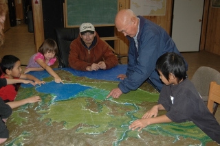
(Click on image to see a Quicktime slideshow)
Grade level: 2
This unit can easily be adapted for grades level 3-8+ and can be even more
appropriate for these higher levels
Standards that may be addressed (for
level 2):
Science
- Asks and answers questions based on observations
and investigations
- Gathers information on topic
- Distinguishes between opinion and fact
- Writes reports and/or gives oral
presentations of experiment and results
- Demonstrates an understanding
that organisms are linked to each other and their physical environments
through the transfer and transformation of matter
and energy
Social Studies
- Places information or constructs charts
and graphs
- Identifies types of social
groups (i.e. family, clan, tribe, village,
neighborhood,
and community).
- Draws local maps
with routes, locations, title, legend and directions
Cultural Awareness
- Participates in some
form of visual arts activity.
- Knows and correctly uses
many different basic
art materials, techniques, and
processes, such
as brushes, pencils,
scissors, clay and paper
Reading
- Demonstrates comprehension
of oral stories
by recalling simple
facts from
a story
Writing
- Engages in purposeful
writing
for specific audiences (e.g.
stories,
reports, letters,
journal
entries).
Technology
- Participates
in
teacher-led digital
communication
project
(i.e. email another
class,
Audio/
video conference,
web
based collaboration).
Skills:
| Cognitive Level |
|
1
1
1
2
3
3
3
3
4
4
6
6 |
Recalling
Answers
Knows
Demonstrates Comprehension
Distinguishes
Uses
Places
Represents
Asks
Gathers
Draws
Writes |
Topics
or Context:
A Two
Month (or
longer) Project
Integrating:
Science,
Social Studies,
Cultural Awareness,
Reading, Writing,
and Technology
-
Construct a
4’x8’ topographic
map or
your area
(a
smaller dimension
can also
be constructed)
-
Collaborate with
elders to
gather and
document knowledge
about the
areas represented
by the
map
-
Create a format
to present
and share
results to
community
Proficiency
Indicator:
Student
participates in
a collaborative class
project while:
asking questions,
making observations,
and gathering
information on
a level
that allows
for results
to be
represented in
a meaningful format
that can
be shared
with others.
Identifying
Big Ideas:
-
We can
conduct investigations
to learn
more about
our environment
by asking
questions, making
observations, gathering
information and/or
results, and
presenting results.
-
Results from
investigations can
be shared
in different
formats such
as reports
or oral
presentations.
-
When information
is gathered
during an
investigation it
can be
categorized as
opinion or
fact.
Essential
Questions to
Guide Instruction
and Assessment:
-
What steps
can take
place during
an investigation
or major
project?
-
How can
we involve
our community
and sense
of place
in the
learning
process?
-
How
can
we share
our
results
in a
meaningful
way with
our
community
and others?
Materials:
USGS
Topographic
Map(s)
(of
the
area
you
wish
to
make
a
3-D
map)
Copy
Machine
and
Paper
Scissors
and
Box
Cutters
Plywood
Board
Glue
(regular
school
glue
is
fine)
Spackle
Acrylic
Paints
and
Paintbrushes
of
various
sizes
Directions: A.
Creating
the
Map
-
Make
a
copy
of
the
USGS
topographic
map(s)
of
the
area
you
wish
to
make
a
three-dimensional
map.
-
You
may
need
to
enlarge
the
USGS
map
in
sections
so
that
it
matches
the
size
of
the
3-D
map
you
wish
to
make.
-
You
will
need
to
trace
the
contour
lines
on
the
copy
of
the
USGS
map
and
it
is
helpful
to
do
this
by
a
color-coded
system
for
elevation
intervals
for
each
area
of
relief
(i.e.
red
lines
for
all
the
first
contour
lines,
blue
for
the
second
contour
lines,
green
for
the
third
lines,
etc.)
-
These
contour
lines
can
then
be
cut
out
from
the
paper
map
(starting
from
the
bottom
or
lowest
level
contour
line)
and
traced
onto
cardboard.
Another
way
to
transfer
the
lines
to
cardboard
is
to
push
a
pin
through
the
paper
along
the
contour
lines
and
into
the
cardboard – this
allows
you
to
start
with
either
the
lowest
or
the
highest
elevation
line.
-
Before
using
box
cutters
or
scissors
to
cut
cardboard
be
sure
to
demonstrate
safe
use
of
these
tools – esp.
with
younger
students.
-
It’s
usually
best
to
glue-as-you-go
by
cutting
out
one
traced
elevation
piece
and
then
gluing
it
to
the
next
level
that
is
cut
out
for
each
area
of
relief.
Often
times
you
will
need
a
stack
of
heavy
books
to
weigh
the
pieces
together
while
the
glue
is
drying.
-
As
you
complete
areas
of
relief,
you
can
glue
them
directly
to
the
board
that
is
being
used
for
the
3-D
map.
-
Once
all
of
the
pieces
are
in
place,
you
will
need
to
apply
a
layer
of
spackle
to
create
a
smoothing
effect
to
the
layered
topography.
This
is
best
applied
with
putty
tools
but
most
kids
like
to
just
apply
it
with
their
fingers.
The
spackle
will
usually
dry
overnight.
-
Paint
can
now
be
applied
using
the
original
USGS
map
for
color
identification.
Google
Earth
is
a
web-based
program
that
can
also
be
helpful
during
this
process.
Details
to
this
process
can
be
added
for
quite
some
time.
-
After
the
map
is
painted,
dry,
and
ready
for
display,
you
are
ready
to
begin
the
next
step.
B. Documenting Knowledge: Information, Stories, History, and
Sense of Place
- Using correct protocols for your community, invite elders
and other community members to share their knowledge with the students.
-
Ask permission to take notes and/or photographs, and use a tape recorder,
or video recorder.
- Preset a topic for discussion but also allow for
any other topics to be discussed. Possible topics may include: How
Have Things Changed,
Where Have
You Been, Climate Change, Memories on the Land, Experiences in the
Area, Sharing Culture, Survival, Sense of Place, Foods, Wildlife,
Topography, Weather,
etc.
- Prepare students ahead of time by giving them time to create
meaningful and on-topic questions.
- Allow for at least an hour per visit.
- If possible, take detailed notes
during each visit.
- Type the notes into a booklet form.
- Allow those involved with discussion
to review the content of the booklet.
- Make corrections if necessary.
- If wanting to include photos, make
sure to ask permission of those photographed.
- Display the booklet alongside
the 3-D topographic map and make the booklet available to those quoted
and to the
students
involved.
- You can allow for further corrections
or additions to be made as time permits.
- If possible, ask permission
for the documented knowledge to be shared with others. This can be
done via a website,
through the Alaska
Native Knowledge
Network (ANKN), with the Northwest Regional Educational
Lab (NWREL), through a conference presentation
or journal article,
and/or
many
other examples.
|