![]()
Day-By-Day Guide
Days 11- 18
Students will be asking people to mark their usual hunting, fishing, or plant gathering sites or areas on maps. After all the interviews have been completed, the information will be combined on one map, showing the places used by everyone in the whole village. This map, along with a calendar showing when hunting and fishing takes place, will be used in this unit and saved for future classes. In order for the maps to be accurate and useful, all of the students need to ask the same questions. They need to make some decisions about these questions in advance, as a group. Here are some things that they will need to consider:
- What resources will they ask about? Now they need to narrow down the resources they have discussed to two that they would like to learn more about (such as seals and tomcod, salmon and blackfish, or moose and berries).
- What seasons and hunting/fishing methods should be covered in the interviews? People use different methods and go to different places to catch the same type of fish or game, depending on the time of the year. For instance, in winter, whitefish are caught in nets under the ice. After breakup, whitefish nets are set in open water. To get complete information about whitefish net sites, students would have to ask about both kinds of fishing, and then mark each type on the map with a different color or using a different symbol.
- Should the class make area maps or site maps? If you ask someone to draw a line around all the places where he usually sets blackfish traps, for example, you will get an area map. A site map, on the other hand, shows the particular spots where someone sets a net, or builds a fish fence, etc. (see example maps). Site maps are useful if you are showing something that people tend to do in the same spot year after year. Area maps are better for showing something like seal hunting, which involves searching a large section of coast. If people are reluctant to talk about exact sites, too, it may be more reasonable to make area maps. Look at the sample interview forms at the end of the project to see what types of questions will result in each kind of map.
- Who should students interview? To answer this, they need to think about the resource in question. Is this something that men are more likely to know about, or women? Should both older or younger hunters be questioned? What other dif-ferences would be important to consider? How many people need to be interviewed to get a good idea of all the areas used by the village? For activities like seal hunting, where everyone hunts more or less in the same area, it may be enough to interview one person from each family group. If each person or group of people uses a different spot for some activity, then more people may need to be interviewed in order to get an accurate picture.
- What time period should be considered? Hunting, fishing, and gathering sites change from year to year. Where a person sets a net, for example, may depend on how high the water is in a particular year, or how much the riverbank has eroded from storms. If you only ask where they set their nets 'last year', you will not have a good overall picture of the places used. The class may choose to ask where nets have been set for the last five years, or twenty years. or over each person's lifetime in the village.
Once students have decided on these questions, they should make up an interview form, or questionnaire, to be used for each of the two resources they have decided to research. Two sample forms and the maps that might result from asking the questions on them are found on the following pages. Note the differences between the questions that would result in a site map, and the questions that would result in an area map.
Five sets of United States Geological Survey Maps are included for your village area. Students will use four of these map sets when they are interviewing people, to record what they are told. On the fifth set, all of the information collected in the interviews will be combined. This map, which will show where all the people interviewed hunt, fish or gather for the two resources, will be used in a class display. Depending on the size of the class, students can be divided in up to four interview teams. Each team should consist of two or three students. Each team will interview people about both of the important resources in question.
Before sending students out to do interviews, the teacher should obtain permission from the people to be interviewed, and set up times for the interviews in advance. The teacher should also review with students the suggestions for conducting interviews and taking notes given in Project I: Yup'ik on the Air. However, during these interviews, students will not need to use tape recorders. They will only need to take notes, and to record the information on the maps. They should be sure to show the map to the person they are interviewing, to check their accuracy. They should also try to record any Yup'ik placenames they are told.
After this preparation, students should practice interviewing each other and taking notes.
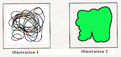
As indicated on the MONTH-AT-A-GLANCE, students will spend the next few days conducting their interviews. They will then combine the information they have been given on one map. Students may find that they have to condense the information they have gathered, in order to make the composite map clear and understandable. This is especially true of area maps. There are two ways to make composite area maps:
1. Draw in the outlines of each of the areas people use, but do not shade them in (see illustration No. 1 below).2. Draw in only the outline of the outer boundary which shows the area where all the people (taken together) look for that resource; then shade in that area (see illustration No. 2 below).
To make the composite map easier to read, it is probably a good idea to leave off the names of individual hunters. Several maps may be taped together to make one large composite map.
![]()
Sample Questionnaire to result in Area Map:
MUSKRAT HUNTING OVER A LIFETIME
NAME OF INTERVIEWERS: Tuntull'er Kumlurpak-lluPERSON BEING INTERVIEWED: Cuukvak
DATE OF INTERVIEW: November 24, 1983
- (After explaining purpose of the activity and showing sample maps, ask:)
- Since you have lived in this area, where have you hunted for muskrat? Please draw a line around the area or areas where you have hunted muskrat during your lifetime?
- When do you usually start hunting muskrats? When do you usually quit hunting them?
- We are trying to learn about how many muskrats our village catches each year. Could you tell us how many you usually catch in a year?
- Are the muskrats you catch usually used in the village, or do you mostly sell them? If the fur prices are high in a particular year, do you try to catch more muskrats?
- Where do other people that you know of usually hunt
muskrats? (We will be asking other people in the village,
but we want to make sure that we learn about all the
areas.)

Naspaatii Apqauriliim Nunanguami:
KANAQLAGNEK PISSULLEQ UNGUVAM TAKTACIATUN
ATKEK APQUARILRIIK: Tuntull'er Kumlurpak-llu
ATRA APQAURUAMALRIIM: Cuukvak
ERNERMI APQAURUMALLEQ: November 24, 1983
(Nalqigqaarluku ciin waten pillren nasvaggaarluki-llu nunanguat, apten:)
- Maa-i uitangrraanerpenek, nani kanaqlagcularcit? Unguvaqallerpeni kanaqlagculallerpet avatait ceterki.
- Cam nalliini kanaqlagcunglarcit? Qakuani-llu pissunrirluten?
- Elitengnaqukut qaill' amllertalrianek kanaqlagnek makumiut unangelauciitnek allamiaqan. (yuinaq, qula, malrugnek cipluku nillarat naanruut.)
- Kanaqlagtaten-qaa makumiuni atutuut, wall'u-qaa tuniaqvallularaten?
- Nani allat yuut nallunrilketen kanaqlagculartat? (Apqaurciqaput maani yuut, taugaam kangingnaurraaryugaput elilluki-llu pissurviit.)
![]()

Sample Questionnaire to result in a site map:
BLACKFISH TRAPPING OVER THE LAST FIVE YEARS
NAME OF INTERVIEWERS: _________________________NAME OF PERSON BEING INTERVIEWED: ______________
DATE OF INTERVIEW: _____________________________
- (After explaining purpose of activity and showing
sample maps, ask:)
1. Where have you set your blackfish traps in the last five years? (Mark all the sites on the map with dots.)
2. Do you set your traps in both streams and lakes? When do you usually put your traps in (streams) (lakes)? When do you usually take your traps out of (streams) (lakes)?
3. We are trying to learn about how much blackfish our village uses/needs each year. Could you tell us about how much blackfish you catch each week (or each season)?
4. If you can't catch very many blackfish, what do you do? (Do you try setting your traps somewhere different? If so, where? So you try for something else? If so what?)
5. Where do other people that you know of set their traps? (We will be asking other people in the village, but we want to make sure that we learn about all the sites.)
At the end of the interview, be sure to thank the person who helped you, and tell them that the class will be making a display of the maps when they have put the information together for the whole village. Your teacher can let the people who were interviewed know when, so that they can come to the school if they want to see the maps.
![]()
Naspaatii Apqaurilriim Nunanguaq:
CAN'GIICURYARAT AUGKUNI TALLIMANI ALLRAKUNI
ATKEK APQAURILRIIK: __________________________
ATRA APQAURUMALRIIM: _____________________
ERNERMI APQAURUMALLEQ: _____________________
(Nalqigqaarluku ciin waten pillren nasvaggaarluki-llu nunanguat, apten:)
- Natumun taluyaten can'giircuutet civtelallrusiki augkuni tallimani allrakuni? (Nallunailkucirki civcivikelaten nunanguami).
- Civtelaraten-qaa taluyat kuiggarnun nanvarraarnun-llu? Cami civcilarcit? Cami yu ug i Ia rc it?
- Elitengnaqukut qaill' amllertalrianek can'giirnek makumiut unangelanciit/aturyulauciit allamiaqan. Qanrutqerkut qaill' amllertalrianek can'giirnek unangelarcit nitilini (wall'u can'giircurnariaqan)?
- Can'giiliquunritaqavet, calarcit? (Naspaalartuten-qaa natmun allanun circiluten? Pilaquvet, natmun? Allanek-qaa unangengnaqelartuten? Pilaquvet, canek?).
- Natmun allat yuut nallunrilketen taluyameggnek
civcilartat? (Apqaurciqaput maani yuut, tangaam
kangingnaurraaryugaput elilluki-llu can'giircurviit).
Apqaunriquvet, quyavikenricaqunaku ikayurtellren, qanrulluku-llu elitnaurat nunanguamek nallunairilriamek paivciciqniluku yuut pikaitnek. Elitnauristem nallunriceciqai apqaurumallret elitnaurvigmun tailuteng tangerrniaraat tangerrsukunegteggu nunanguaq.

last page | table of contents | next page